Thursday, April 22, 2010
Sony GPS DSC-HX5V
Sony unveiled a new digital camera with GPS for the CES 2010. The new point and shoot Sony digital camera with GPS is the Sony Cybershot model DSC-HX5V.
The DSC-HX5V is the first point and shoot camera to support SD and SDHC cards and the Transferjet cards. Transferjet cards let you share files between transferrjet- enabled devices by bringing the devices one inch closer to one another.
Sony claims that this is one of the world's smallest and thinnest Advanced Video Codec High Definition capable cameras, with a resolution of 1980X1080. The Sony Cybershot DSC-HX5V has 10x optical zoom, a 10-megapixel back-illuminated Complementary Metal Oxide Semiconductor (CMOS) sensor, and built-in GPS and compass. The optical steadyshot improved optical stabilization helps to reduces blur without losing image quality. It also helps the user to take good images of moving objects. Think of taking pictures of your kids at play! The camera also has the face detection and smile shutter technologies. So the face and the smile can be taken naturally.
The main feature of DSC-HX5V is the GPS geotagging and the internal compass. So when you travel between time-zones the time on the camera will get updated automatically. You can also use the Google maps to find the best spots to take pictures. The user can check on Google Earth to know the location and also can get a bird’s eye view. The geotagging will be helpful to remember where the images are taken. The camera has outstanding lowlight performance. Thanks to Sony's back illuminated CMOS sensor technology. The ‘’Intelligent Scene Recognition’’ will create 9 different views and selctes the optimal camera settings within the fraction of a second.
Features and Functions
The important special feature of Sony DSC HX5V camera is the built in GPS and compass. It helps to use Google Earth to get different views of the location.
Other features are the face detection, smile shutter, low light performance, 10 frames per second image capture, 10X optical Zoom, and the optical steady shot image stabilization. The camera comes with battery charger, wrist strap, multi connector cable, software, power cord and the HDMI adapter.
Tanita BC-568 InnerScan Segmental Body Composition Monitor
This scale seems to have it all for a consumer body monitor. I like the body fat and water percentages. The version that connects to the computer wirelessly doesn't have so many functions.
Wednesday, April 21, 2010
Ayo Technology
Here is a compiled list that are interesting which I have yet to buy:
Shoes
Hydration Systems
Running/Swim GPS Watch
Bike
Shoes
Hydration Systems
Running/Swim GPS Watch
Bike
Kestrel 4000 Meter
I bought this several years ago when I got interested into kiting. It's great device to know the wind speed, temperature and humidity. I used it during my Hong Kong Marathon. I left the interface in America so I can't download the data, but too much data is information overload.
Garmin 405CX GPS Watch
I bought this in America; October 2009. Overall it has been good. The only qualm I have with it is that the bezel becomes inoperable when I oversweat and the battery power. The footpod is very useful if you run under tunnels or lots of buildings. It prevents the autolap feature from going haywire.
I've notice that most runners prefer 310XT since it is waterproof, 14 hours longer, and $20 cheaper!
After reviewing other runner stats, it appears there are accuracy problems with the 310XT. I have 405CX and although it's far from perfect, I notice that it doesn't have wacky errors of creating 1:30/km for 1k lap. During the SCHKM, I compared my stats with a friend who ran with the 310XT and his went berserk especially near the tunnel. I believe using footpod increases this accuracy when the satellite can't be found.
Well, this watch WAS working as of 04/27/2010. Now, it's used as a paper weight. I talked to the Garmin Rep in USA and I have to contact Taiwan Rep. Unfortunately they never pick up. I found that the problem is with the watch. I hope I can get it repaired before my 1/2 marathon race in Busan, Korea. I doubt it. Now, I just use my $30 Nokia phone to keep track of my times.
Another note is that the 405CX definately has better GPS/software than 310XT. I believe if you are a true numbers runner, you'll appreciate the better accuracy of the 405 than the 310 even with it's flaws.
Monday, April 19, 2010
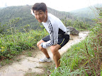
Lantau 2 Peaks Run #2
http://connect.garmin.com/activity/30385181
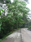
I found some other facebook runners around Hong Kong and one of them mentioned that they would run from Mui Wo to Big Buddha; eat and run back. Well, running that much in one day is too much for me; so this week, I gave it a stab to run it backwards. I initially thought I would try to end up near Discovery Bay... but, well - getting lost in the beginning changed my mind. I woke up early again (5:30AM) and headed toward Tung Chung; I arrived an hour earlier than last week since I don't need to wait for the boat. Once in Tung Chung..
I started to run and realized that I was going the wrong way! It is always difficult to remember which way to go when you try to visually stamp it on your forehead via google maps; next time I should bring a map.. but it'll just get wet and the sweat/rain and the fact that most of the runs are on trails make it more difficult to figure things out.

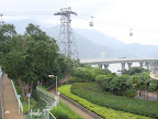
I located the point of entrance after running 4k later. I figured it would be straight in and up. Well, my mistake since after seeing public bathrooms... there is a big fork in the road. I used my best logic and decided to go straight. Try #1: Dead end; met a lady who told me it's near the bathroom and back I went. Ok try #2, let's try left turn (direction of the cable cars).. found a small "village" and cemetary only to find another dead end.

Tried another road but led to a mean unleashed barking dog. 3k later, I was on the right track... 400m and 3.5k later, I linked up with the Lantau trails.
It's now 2k and another 430m up to the first peak. The wind was so strong.. I video taped some parts of it and you can hear the wind just howl.
Everything was very cloudy and luckily I took some pictures of the Buddha and surrounding areas before the massive cloud mist rolled in.
Sunset peak was no different..

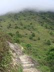
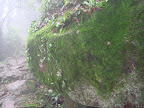
Although this peak is shorter in height, the run up to this peak is a little longer and steeper. I thought I was at the top; but, it kept on going higher. Just like the run up to Ngong ping, the run down is similar with woods, even including green moss.
After hitting pavement, I knew it was mostly downhill with a faster pace to finish up in Mui Wo.
For those interested in racing a similar course across Lantau 2 Peaks, try: Map.
I found some other facebook runners around Hong Kong and one of them mentioned that they would run from Mui Wo to Big Buddha; eat and run back. Well, running that much in one day is too much for me; so this week, I gave it a stab to run it backwards. I initially thought I would try to end up near Discovery Bay... but, well - getting lost in the beginning changed my mind. I woke up early again (5:30AM) and headed toward Tung Chung; I arrived an hour earlier than last week since I don't need to wait for the boat. Once in Tung Chung..
I started to run and realized that I was going the wrong way! It is always difficult to remember which way to go when you try to visually stamp it on your forehead via google maps; next time I should bring a map.. but it'll just get wet and the sweat/rain and the fact that most of the runs are on trails make it more difficult to figure things out.
I located the point of entrance after running 4k later. I figured it would be straight in and up. Well, my mistake since after seeing public bathrooms... there is a big fork in the road. I used my best logic and decided to go straight. Try #1: Dead end; met a lady who told me it's near the bathroom and back I went. Ok try #2, let's try left turn (direction of the cable cars).. found a small "village" and cemetary only to find another dead end.
Tried another road but led to a mean unleashed barking dog. 3k later, I was on the right track... 400m and 3.5k later, I linked up with the Lantau trails.
It's now 2k and another 430m up to the first peak. The wind was so strong.. I video taped some parts of it and you can hear the wind just howl.
Everything was very cloudy and luckily I took some pictures of the Buddha and surrounding areas before the massive cloud mist rolled in.
Sunset peak was no different..
Although this peak is shorter in height, the run up to this peak is a little longer and steeper. I thought I was at the top; but, it kept on going higher. Just like the run up to Ngong ping, the run down is similar with woods, even including green moss.
After hitting pavement, I knew it was mostly downhill with a faster pace to finish up in Mui Wo.
For those interested in racing a similar course across Lantau 2 Peaks, try: Map.
Subscribe to:
Posts (Atom)